

CONTRIBUTION DES SIG DANS LE SYSTEME D’INFORMATION ENVIRONNEMENTAL DU LAC KOKO
Date de Publication : Octobre 2021 | RGO 10 Volume 01 | Page No.:55-71
ISSN : 2424-7375
Télécharger PDF
RESUME : La contribution des SIG dans l’application des SIE est innovatrice.
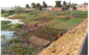
Ces outils sont nécessaires pour la gestion de l’environnement autour du lac
Koko situé dans la ville de Korhogo. Face aux conditions drastiques du
climat dans le nord et l’usage abusif du lac Koko (abreuvage de bétail,
irrigation des cultures, adduction en eau potable), une prise de conscience
visant la protection de l’environnement a permis de pallier le déficit hydrique
que connaît la ville de Korhogo. Le SIE se veut le cadre de l’ensemble des
interactions entre les producteurs de données environnementales et les
utilisateurs de données sur le lac de Koko. Ces données dans le cadre du SIG,
ont permis de faire ressortir la diversité des composantes de l’environnement
autour de la retenue d’eau qui interagissent de manière régulière et
interdépendante. Les analyses s’articulent autour des problèmes, des
paramètres environnementaux et des aménagements. La présente étude a pour
objectif d’intégrer les SIG dans l’organisation des composantes du Système
d’information environnementale. Elle s’appuie sur une recherche
documentaire, des enquêtes de terrain et l’utilisation des logiciels appropriés.
Cette intégration permettra des interactions entre producteurs de données
environnementales et utilisateurs de données géographiques.
Mots clés : Système d’Information Géographique, Système d’Information
Environnemental, Environnement, Korhogo, Côte d’Ivoire.
ABSTRACT:
Contribution of GIS in the environmental information system of Lac Koko
The contribution of GIS in the application of EIS is innovative. These tools
are necessary for the management of the environment around Lake Koko
located in the town of Korhogo. Faced with the drastic climate conditions in
the north and the abusive use of Lake Koko (watering livestock, irrigating
crops, drinking water supply), awareness aimed at protecting the
environment has made it possible to overcome the water deficit. that the
town of Korhogo knows. The EIS is intended to be the framework for all
interactions between producers of environmental data and users of data on
Lake Koko. These data, in the context of the GIS, made it possible to
highlight the diversity of environmental components around the water
reservoir, which interact on a regular and interdependent basis. The
analyzes revolve around problems, environmental parameters and facilities.
The objective of this study is to integrate GIS into the organization of the
components of the Environmental Information System. It is based on
documentary research, field surveys and the use of appropriate software.
This integration will allow interactions between producers of environmental
data and users of geographic data.
Key Words : GIS, EIS, Environment, Korhogo, Côte d’Ivoire.