

DYNAMIQUE SPATIO-TEMPORELLE DE L’OCCUPATION DES TERRES DANS LES FORETS CLASSEES DE SONGAN ET TAMIN, SUD-EST DE LA COTE D’IVOIRE
Date de Publication : Octobre 2022 | RGO 11 Volume 01 | Page No.:187-210
ISSN : 2424-7375
Télécharger PDFRESUME : Le développement et l’essor des cultures du café et du cacao, principale source de revenus des populations a occasionné dans le Sud-est, une anthropisation massive de l’espace conduisant à une raréfaction des terres agricoles. Face à cette situation, la population riveraine des forêts classées de Songan et de Tamin n’hésite pas à les infiltrer pour y aménager des parcelles de cultures. La présente étude menée sur ces deux forêts classées, avait pour but d’évaluer les surfaces forestières à travers une analyse spatio-temporelle de l’occupation des terres. Ainsi, une classification dirigée pixel par pixel basée sur le maximum de vraisemblance a été appliquée à deux images satellitaires (Landsat TM et OLI8). Les images classifiées ont été vectorisées et exportées dans un logiciel de Système d’Information Géographique pour analyse et réalisations des cartes.
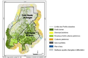
Les résultats obtenus ont révélé que le couvert forestier dans la forêt classée de Songan connait une forte régression avec un taux de couverture forestière qui est passé de 82 % en 1989 à seulement 19 % en 2019, soit un taux de régression global de plus de 77 % sur la période représentant un taux de régression moyen annuel d’environ 5 %. Les formations forestières dans cette aire protégée ont presque toutes été remplacées par les cultures pérennes.
Au niveau de la forêt classée de Tamin, la situation n’est pas non plus reluisante même s’ils y subsistent encore des ilots de forêts au milieu des cultures. Le taux de couverture forestière dans cette aire protégée est passé de 77 % en 1989 à 53 % environ en 2019, soit un taux de régression global de plus de 31 % en 30 ans représentant un taux de régression moyen annuel de 1,25 %.
Ainsi, la raréfaction de la rente forestière et l’intensification des activités agricoles autour des forêts classées de Songan et de Tamin ont entraîné une déforestation de ces dernières au profit des surfaces agricoles.
Mots clés : occupation des terres, déforestation, Forêt classée de Songan et de Tamin, Sud-Est de la Côte d’Ivoire.
ABSTRACT:
Spatio-temporal dynamics of land occupation in the classified forests of Songan and Tamin, south-eastern Côte d’Ivoire
The development and growth of coffee and cocoa crops, the main source of income for the populations, has caused in the South-East, a massive anthropization of the space leading to a scarcity of agricultural land. Faced with this situation, the local population of the classified forests of Songan and Tamin does not hesitate to infiltrate them to develop plots of crops. The present study carried out on these two classified forests, aimed to evaluate the forest surfaces through a spatio-temporal analysis of the land occupation. Thus, a pixel-by-pixel directed classification based on maximum likelihood was applied to two satellite images (Landsat TM and OLI8). The classified images were vectorized and exported to Geographic Information System software for analysis and map production.
The results obtained revealed that the forest cover in the classified forest of Songan is experiencing a strong regression with a forest cover rate which fell from 82% in 1989 to only 19% in 2019, an overall regression rate of more than 77% over the period representing an average annual regression rate of approximately 5%. The forest formations in this protected area have almost all been replaced by perennial crops.
At the level of the classified forest of Tamin, the situation is not good either, even if there are still islands of forest in the middle of the crops. The forest cover rate in this protected area fell from 77% in 1989 to approximately 53% in 2019, an overall regression rate of more than 31% in 30 years representing an average annual regression rate of 1.25%.
Thus, the scarcity of forest revenue and the intensification of agricultural activities around the classified forests of Songan and Tamin have led to deforestation of the latter in favor of agricultural land.
Key Words : land occupation, deforestation, Songan and Tamin Classified Forest, south-eastern Côte d’Ivoire.
.
.
.