

IDENTIFICATION ET QUANTIFICATION DES ÉCHANGES NAPPE-RIVIÈRES PAR ANALYSE SPATIALE DANS LE BASSIN VERSANT DU KOU
Date de Publication : Octobre 2022 | RGO 11 Volume 03 | Page No.:85-102
ISSN : 2424-7375
Télécharger PDF
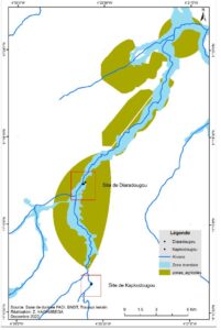
RESUME : La partie ouest du Burkina Faso regorge d’importantes ressources en eau tant superficielle que souterraine. Les eaux souterraines et de surface constituent une ressource naturelle importante, tant pour l’approvisionnement en eau des populations, l’hydraulique agricole et pastorale que pour l’équilibre écologique des écosystèmes. En effet, les eaux souterraines sont en interaction permanente avec les eaux superficielles. Ainsi, les échanges existant entre les eaux souterraines et les cours d’eau assurent les débits dans chacun des réservoirs, mais influencent également la qualité des eaux. L’objectif de ce travail vise à identifier et à quantifier les échanges entre la nappe souterraine et le fleuve Kou par analyse spatiale. L’approche adoptée a consisté à l’utilisation des techniques d’analyse spatiale sous SIG et la loi de Darcy pour l’identification et le calcul du sens et du débit des échanges entre la nappe et la rivière. Cette étude montre qu’en amont de la zone d’étude, dans le site de Kapkodougou, la nappe alimente la rivière en rive droite sur une longueur de 30 m avec un débit de 52.36 m3/j. Pour la même saison en aval de la zone d’étude, dans le site de Diaradougou, la rivière alimente la nappe sur les 160 m avec un débit de 114.36 m3/j.
Mots clés : Échanges nappes/rivière, rivière Kou, analyse spatiale, TIN, Loi de Darcy.
ABSTRACT: The western part of Burkina Faso is full of significant surface and underground water resources. Groundwater and surface water are an important natural resource, both for the water supply of populations, agricultural and pastoral hydraulics and for the ecological balance of ecosystems. Indeed, groundwater is in constant interaction with surface water. Thus, the exchanges existing between the groundwater and the watercourses ensure the flow rates in each of the reservoirs, but also influence the water quality. The objective of this work is to identify and quantify the exchanges between the groundwater and the Kou River by spatial analysis. The approach adopted consisted in the use of spatial analysis techniques under GIS and Darcy’s law for the identification and calculation of the direction and flow of exchanges between the groundwater and the river. This study shows that upstream of the study area, in the Kapkodougou site, the aquifer feeds the river on the right bank over a length of 30m with a flow rate of 52.36m3/d. For the same season downstream of the study area, in the Diaradougou site, the river fed the aquifer over 160m with a flow rate of 114.36m3/d.
Key Words : cloths Exchanges / river, river Kou, spatial analysis, TIN, Darcy law.
.
.
.